
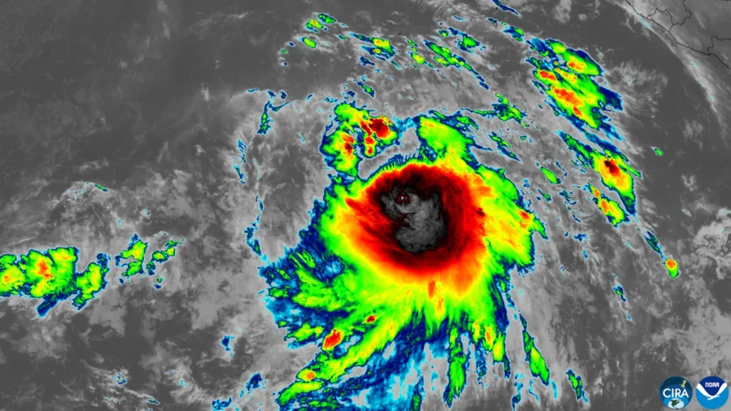
Hurricane Simon has strengthened into a dangerous Category 4 storm off Mexico’s Pacific coast, packing sustained winds of 150 mph (240 kph) as it barrels toward landfall between Manzanillo and Puerto Vallarta, expected late Saturday or early Sunday.
The U.S. National Hurricane Center (NHC) said on Saturday morning that Simon was located about 115 miles (185 km) south-southwest of Manzanillo and moving northward, with some additional strengthening possible before it reaches the coast. It is the latest major storm in what has become one of the most active Pacific hurricane seasons ever recorded.
Where Will Hurricane Simon Make Landfall?
Forecasters expect Hurricane Simon to approach Mexico’s west-central coast as a major hurricane late Saturday or early Sunday, with landfall most likely between Manzanillo — Mexico’s largest Pacific port and the country’s main gateway for trade with Asia — and Puerto Vallarta, a beach destination of nearly 300,000 residents.
A hurricane warning is in effect for portions of Mexico’s Pacific coast south of Puerto Vallarta, including the area around Manzanillo and the offshore Islas Marias archipelago. A tropical storm watch extends farther south toward Lazaro Cardenas. The NHC has urged residents in the warning zone to rush preparations to protect life and property.
How Strong Is the Storm?
Simon reached Category 4 strength — defined as sustained winds of 130 to 156 mph — after one of the fastest intensification runs of the season. On Friday morning it was only a Category 1 storm with 100 mph winds; by Friday afternoon it was nearing Category 3 at 110 mph, and by Saturday it had hit 150 mph.
“Simon has strengthened incredibly quickly, and that’s what makes storms like this so dangerous,” said AccuWeather meteorologist Dan Pydynowski. Strong winds could damage homes and businesses, while flooding and mudslides could wash out roads and cut off communities from emergency crews, he said.
AccuWeather senior meteorologist Tyler Roys said Simon “could deliver the most significant hurricane impact to this stretch of the Mexican Pacific coast since Lidia in 2023, which damaged thousands of homes and devastated crops along the Jalisco coast.”
What Are the Biggest Dangers?
The greatest threat from Hurricane Simon may be water, not wind. The NHC expects the storm to dump 10 to 20 inches (25 to 51 cm) of rain across southwestern Mexico through Sunday, with isolated totals of up to 30 inches (76 cm) possible in parts of Michoacan, Colima, and Jalisco.
That rainfall could trigger life-threatening flooding and mudslides, especially in mountainous areas, according to the NHC. Mexican authorities have warned of heavy rainfall in the states of Guerrero, Michoacan, Colima, and Jalisco, and the storm is also expected to push a dangerous storm surge onto the coast near the point of landfall.
Mexico’s national civil protection coordinator, Laura Velazquez, urged residents to stay indoors in their homes or move to temporary shelters while the hurricane passes. The Mexican Navy has activated emergency response personnel in Colima and restricted maritime traffic along parts of the Pacific coast, closing ports to smaller vessels. In Manzanillo, fishermen have been hauling their boats off the beach, and authorities have raised black flags signaling the beach is closed.
Why This Hurricane Season Is Historic
Simon is arriving at the peak of a hyperactive Pacific season. According to Colorado State University, the region’s Accumulated Cyclone Energy (ACE) — a measure of a season’s total intensity and longevity — reached 304.0 through Friday afternoon, making 2026 the second-most active northeastern Pacific season on record. The record stands at 318.1, set in 2018, and an average season scores just 132.7.
The storm also follows days of disaster across the region: a magnitude 7.6 earthquake shook Panama on Friday, triggering tsunami alerts, and post-tropical storm Isaias left hundreds of thousands without power across the U.S. Southeast after making landfall in Florida.
What’s Next?
Hurricane Simon is expected to make landfall late Saturday or early Sunday and then weaken as it moves inland — but the danger will not end at the coast. The NHC warns that life-threatening flooding and mudslides can occur well after a hurricane’s winds die down, especially in mountainous terrain already soaked by days of rain.
Residents from Michoacan to Nayarit are being urged to complete preparations now and heed evacuation orders. This is a developing story, and NovaHub will update it as landfall reports come in.
Based on reporting by Reuters, The Weather Network, and the U.S. National Hurricane Center.